Look across the season
I compare possible days on familiar routes without starting the preparation again each time.
 Connected Sailing
03 / Before we go
Finding a date and tidal window that suit my passage.
See how it helps ↓
How it helps me aboard Jocelyn
I compare possible days on familiar routes without starting the preparation again each time.
I consider outward and return times, the stay and arrival conditions together.
I send an approved calendar preview to Connected Sailing and use it as the starting point for my passage plan.
For a favourite route, the calendar compares predicted journey times using the available tidal streams and my chosen boat speed. It helps me see promising dates together, including the return, rather than repeatedly starting the same planning exercise.
I set departure windows for the outward and return journeys, along with how long I want to stay. The Sailing Diary on the Mac then helps compare the tidal opportunities within those choices: favourable streams, predicted passage times and arrival conditions, rather than simply the earliest possible start.
A quick passage is not much use if I arrive at an awkward time. I can include arrival conditions, examine the timed journey and consider what happens if Jocelyn is slower than planned.
I add the outings I choose to my sailing diary and send the approved calendar and prepared journey previews to Connected Sailing on the iPad and iPhone. On the iPad, I can turn a calendar journey into a passage plan and open its timed map while sailing. The previews also show when their predictions were obtained and when they need refreshing.
The planning now brings UK information together with imported Dutch tidal heights and streams for their available dates. Coverage and gaps matter: a date outside an import is not silently treated as having Dutch predictions.
Connected Sailing’s Home weather card shows when the forecast was downloaded. When I open or return to the app, it requests a fresh position for the nearest UK area suggestion; I can also choose another area myself.
Expanding the card brings the 12-mile Inshore forecast and Shipping forecast together, with their named areas, dates and original Met Office wording. The Inshore display shows broad wind views for the first and second 12 hours, followed by the separate outlook for the next 24 hours. I read the wind, sea state, weather and visibility and make my own judgement: the app does not assess the forecast against sailing limits.
Refresh updates the official sources independently, and saved forecasts retain their original dates if a download fails. Links to the official forecasts remain available. With my route-less Day Sailing pack selected, this familiar UK display stays as it is. The Mac Companion also provides forecast references, while current conditions, the whole route, tidal races and entrances still need my own review.
When I select a Passage Awareness Pack containing a route, Connected Sailing suggests forecast areas along that journey. For a Suffolk to Flushing crossing, I can bring the UK Inshore area, Thames Shipping forecast, Belgian coast and KNMI Flushing coastal forecast together. I can review the areas, select others within the supported coverage and download them before departure. A fresh position helps with nearby-area suggestions while the areas ahead remain available. Extra route forecasts only activate for the selected pack’s usable route; switching back to Day Sailing stops those extra downloads.
The Dutch coastal bulletin is available in English. Other non-English forecast narratives and warnings are translated automatically into English, with their original wording retained. Language files may need a first download on the device. Each provider keeps its own issue time, download time and published periods: Dutch first and second 12 hours, Belgian dated day parts, and the UK Inshore forecast and outlook. I do not want missing sea-state information or precise times invented where the source does not provide them. This currently covers UK, Dutch and Belgian sources; French, Spanish and other coastlines are not yet included.
While the app is open, the selected route forecasts are checked every 15 minutes and checked again when I return to it. I can also refresh them myself. If internet drops, failed sources retry every minute; earlier downloads remain readable offline with their original dates. I still read the official warnings, check the coverage boundaries and make the sailing judgement myself. Downloads need working internet, and iOS can suspend an app in the background.
Below the forecasts, I can open the map on the iPad or iPhone, zoom into the area I want and download the available predictions. Wind, Waves, Streams and Boat share the same selected time. Blue wind arrows show direction with small wind-speed numbers in knots; purple wave arrows and values show wave travel and significant wave height in metres. I can move through the available forecast hours, with each source keeping its own coverage and dates. The map is available from Home weather, passage planning and Weather during a passage.
I tap the Boat map to place a planning boat, choose a speed through the water and set a true heading. I can also hold the nearest route leg. The calculation combines forecast wind with the boat’s movement and an available tidal-stream prediction to estimate apparent wind and the likely point of sail. The closest available valid stream point is selected automatically; even farther offshore it can use a more distant point, showing its name and distance. I can override that choice or enter a stream myself. A distant point is an assumption about local flow, not a continuous current map.
The larger boat now shows a gold mainsail and pale blue foresail, with an apparent-wind arrow. The sails turn with the heading and mirror with the wind side; the point of sail and apparent-wind angle stay readable directly beneath the boat. I can see close reach, beam reach or broad reach without scrolling to the detailed result. This is a visual illustration, not instructions for sail trim. It does not model leeway, wave motion or Jocelyn’s performance; missing information is shown explicitly rather than guessed.

Weather along my route
These examples show the new route-area list and Dutch and Belgian forecast details. They are real shared interface renders with an illustrative route and dated downloads from 7 October 2026, not current sailing advice.
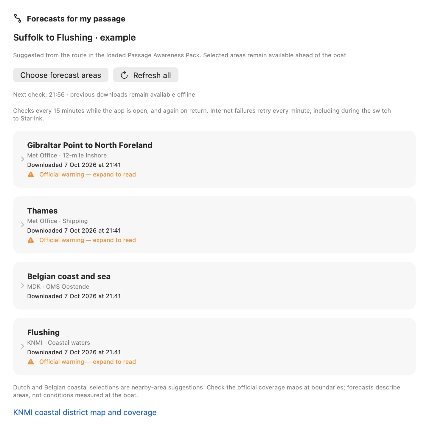
An illustrative Suffolk–Flushing route brings four sources together: UK Inshore, Thames Shipping, Belgian coast and KNMI Flushing. This is the actual shared forecast view rendered on the Mac, with dated public-source downloads from 7 October 2026.
Enlarge screenshot ↗
The KNMI coastal bulletin shows its first and second 12-hour periods, wind directions, original English wording and official warning. This is the actual shared forecast detail from 7 October 2026, not a forecast for a future departure.
Enlarge screenshot ↗
A cropped detail of the first Belgian published day part shows wind direction, force, coastal wave height and weather in English. The full card continues with later day parts and the original narrative. This example is dated 7 October 2026.
Enlarge screenshot ↗My weather map and sailing angle
These are real interface examples from the installed 12 October update, using isolated demonstration data. They show the Boat, Wind and Waves displays; the Streams tab provides available point predictions at the same selected time. The examples are not current weather, tide predictions or sailing advice.
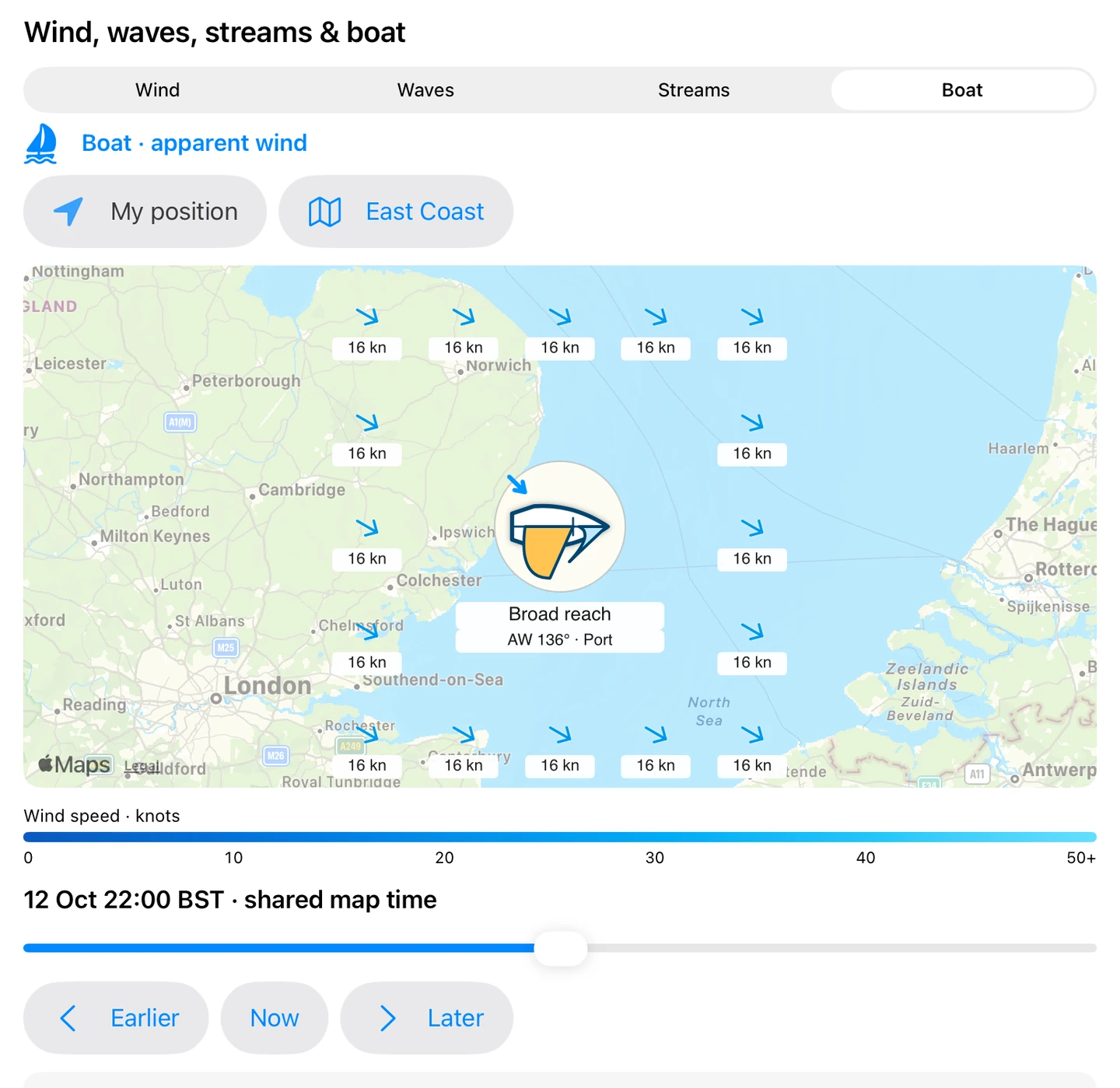
I place the boat and choose its speed and heading. Here the illustrative mainsail, foresail and apparent-wind arrow show a broad reach, with the angle and wind side directly below the boat. The example uses a chosen 4.5-knot speed through the water. The sails are a visual guide to the point of sail, not trim instructions.
Enlarge screenshot ↗
This separate close-reach example shows the same boat illustration and upright caption in Night Watch. Gold mainsail, pale blue foresail and the blue apparent-wind arrow remain distinct. Changing the forecast hour, heading or current-adjusted apparent wind updates the illustration.
Enlarge screenshot ↗
Blue arrows show wind travel and small numbers show speed in knots. I can pan or zoom, download the visible area and move through the available forecast hours. The map retains the source’s coverage and original dates; it does not make a weather-limit judgement for me.
Enlarge screenshot ↗
Purple arrows show wave travel, with significant wave height in metres. Waves share the selected map time with Wind, Streams and Boat, but retain their own forecast end. This helps me keep the layers separate when tired or using Night Watch.
Enlarge screenshot ↗Interface examples from 12 October 2026, using isolated demonstration data. These are not current weather or tide predictions.
My setup on screen
I read the UK forecast, explore a chosen tidal time and inspect the curve. The forecast judgement stays with the skipper; the screenshots use demonstration data.

A detail of the current forecast layout: wind symbols sit beside the original wind, sea-state, weather and visibility wording. Historical demonstration forecast from 7 September, not current weather or advice.
Enlarge screenshot ↗
The tidal explorer combines the selected time, stream display and tide curve. This is a UK demonstration from the current app; availability and validity of the underlying predictions still need checking.
Enlarge screenshot ↗
A detail of the tidal-height display for a UK station, using synthetic test predictions. The orange marker lets me examine a time on the curve. It is an interface example, not a tide prediction for use.
Enlarge screenshot ↗It connects with…